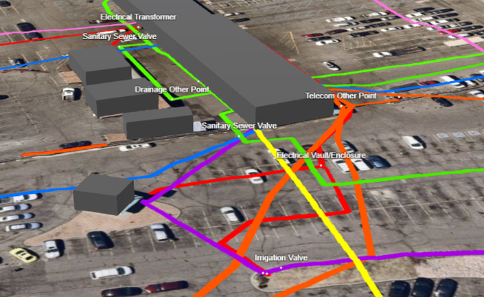
Utility Mapping Special Projects is an online training course that walks students through advanced mapping and GIS workflows for surveying and mapping underground utilities.
This training reveals our best kept utility mapping and GIS secrets.
Sign up and watch how our certified GIS professionals deliver utility maps and data!
Why You Should Take This Training
Our video lessons are given by highly-qualified and certified GIS professionals with extensive GIS & Utility Mapping training and experience.
- This training provides a formal instructor-led experience.
- Students use the latest and greatest industry-leading mobile mapping technology.
- Gain exposure to the most advanced & affordable mobile mapping technology.
About This Training
This instructional training teaches students how to map, manage, and document utility data using a wide variety of hardware and software.
No prior utility mapping or GIS experience is necessary.
These are fast-paced lessons with sample data and map files for following along.
Requirements
- Students should have 0 - 10+ years experience with Utilities, GPS, GIS, GPR, & CAD.
- Students should be familiar with various data formats: KML, CSV, Shapefiles, DXF, DWG, CAD.
- Students should be eager to learn how to map and manage critical utility data.
Who This Course Is For?
- Utility Locators, GPR Technicians, CAD Drafters, Surveyors, GIS Technicians, GIS Analysts, Utility Engineers, Directional Drillers, high school students, and college students.
- This course is meant for those looking for hands-on experience mapping utilities using mobile and web-based GIS, GPS, Pipe Locators, and Augmented Reality.
- This course is great for students interested in sharpening their GIS, utility mapping, and data management skills.
- This course is perfect for surveying, utility locating, and SUE firms that want to expand their deliverables and stand apart from competition by offering GIS as a service.
- Anyone interested in learning how to map underground utilities using GIS.
Your Instructor
Tyler Bristow is a certified GIS Professional (GISP) with over 12 years of experience providing GIS consulting for local and federal governments, mid-sized municipalities, and large industrial facilities using various GPS, GIS, & CAD technology. Tyler provides utility mapping consulting and training for utility companies, locating firms, surveyors, and civil engineers.
Course Curriculum
-
StartLegal Disclaimer and Terms of Use
-
StartProject 1 - Build a 3D GIS Application using PointMan KML Data (18:51)
-
StartProject 2 - Host a 3D GIS Application on Your Own Website (4:39)
-
StartProject 3 - From PointMan Plus to PDF Maps in Minutes (19:22)
-
PreviewProject 4 - How To Add Drone Imagery to Your Maps (21:32)
-
PreviewProject 5 - Collect Data using the R1 Plus Total Station (41:39)
-
StartProject 6 - Adding the R1 Plus Total Station Data to GIS Software (24:37)
-
StartProject 7 - Collect Data using the R80 Robotic Total Station (30:38)
-
StartProject 8 - Importing data from Cube-a to Desktop and Cloud GIS (29:54)
-
PreviewProject 9 - Adding Google Basemaps to QGIS Software (11:00)